
G’day there!
In fairness to those of my readers who may not know where exactly Prince Edward Island is situated, I felt it best to kick things off with a geographical primer of sorts. And because this is a blog rooted in all things Island history, what better way to do so than to examine PEI’s cartographic history and its two-dimensional evolution over the years?
Big or small, old or new, simplistic or detailed, or by times downright convoluted, there’s no denying that maps are an exceptional tool for historical study and enlightenment. They’ve always been something of a hobbyhorse of mine, and believe it or not, Prince Edward Island actually has its fair share. (Fun fact: Did you know that, at one time, a map of PEI was the most accurate map ever produced? Keep reading to learn more!)
But first, let’s get a better handle on PEI’s place in the world today:
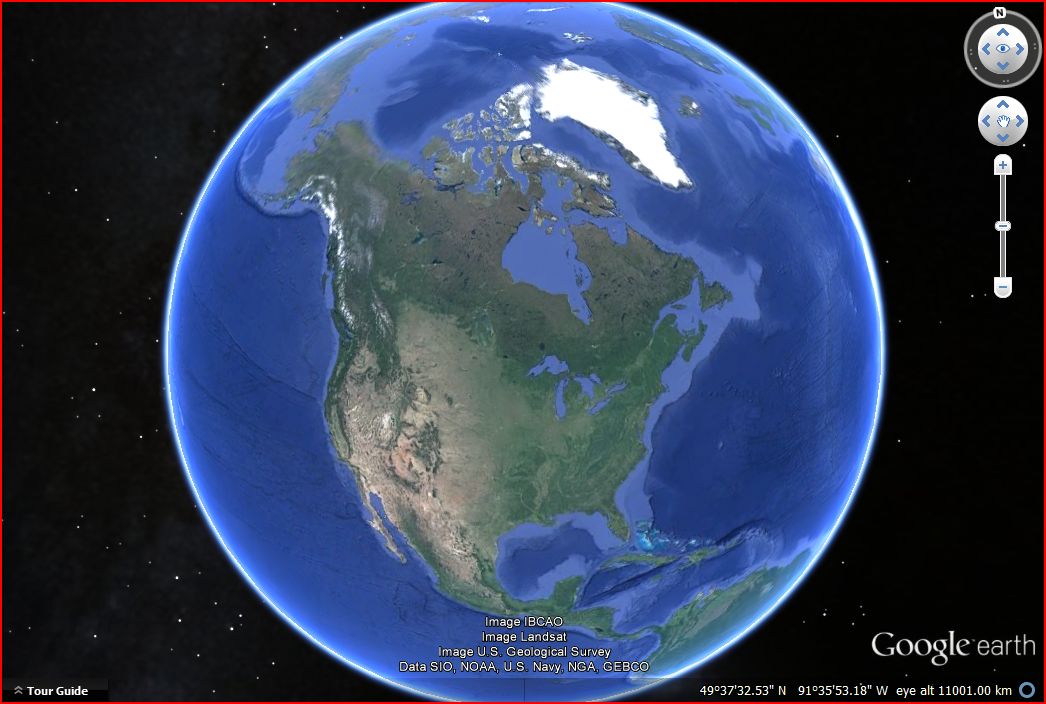


As you can see, Prince Edward Island is in Atlantic Canada, along with Nova Scotia, New Brunswick, and Newfoundland. (Fun Fact: Did you know that PEI almost ended up with “New” in its name? More on that in a future post!) You also get a sense now of just how small this island is relative to the rest of Canada, and how everyone could know everyone else! But you didn’t come here for modern satellite imagery, so let’s move on to the good stuff.
I imagine you’re probably wondering what the oldest map is of Prince Edward Island, or that at least shows the Island in relation to the rest of the world. Well, there’s still quite a bit of disagreement over this. There are a number of people, both here and abroad, who subscribe to the theory that PEI is the celebrated Vinland of the Norse sagas, a place somewhere in the Atlantic that was discovered by Leif Eirikson in the 11th century. The only clues we have reside in the Sagas, which provide vague directions that eventually lead you to North America. The reason I bring all of this up is that there exists a map which claims to portray an island labelled “Vinland”, somewhere to the west of Greenland, in an area that could be interpreted as Atlantic Canada. The problem, however, is that this map has polarized the academic community into those who believe it to be genuine, and those who consider it a 20th century forgery. In all its glory, I give you the (in)famous Vinland Map:

Originally thought to have been produced in the 15th century based on 11th century information contained in the Sagas, it is now widely believed to be a high-calibre forgery done up in the 20th century with the use of period materials. Personally, I don’t know enough about this map to offer an opinion one way or the other; it’s just that, IF PEI is Vinland, and IF this map is genuine, then what we have is the oldest map on record that depicts the Island. But as of this moment, those are two pretty big ifs (however, feel free to drop me a comment if you’d like to weigh in on this debate).
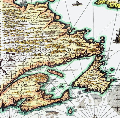
Maps of/showing Prince Edward Island appear only sporadically in the 16th and 17th centuries following its “discovery” by John Cabot (1497), and Jacques Cartier’s claiming it for France in 1534. This reflects a) the fact that the settlement of the New World was in its infancy during this time, and still relatively unknown to cartographers, and b) the tiny size of the Island in relation to everything around it. There are even “detailed” maps of North America from this period that omit PEI completely. Seriously. Check out this 1616 map of eastern North America by the explorer Samuel de Champlain. I’ve cropped it to show the Atlantic Canadian region, and placed a red question mark where PEI should be situated.

I suppose we shouldn’t be too hard on poor Samuel, although the irony of an intrepid explorer omitting a landmass whose existence had been recognized by Europeans for at least the past 100 years, a landmass bordering one he actually stepped foot on, needs to be pointed out. Not to mention the fact that, in 1584, cartographer Jacques de Vaulx produced a map that was the first to accurately situate the Island in the Gulf of Saint Lawrence. To his credit though, Champlain did remedy this blunder 16 years later, updating his map in 1632.
Over the years, cartographers, by and large, became more adept at capturing the Island’s crescent shape, but their accuracy was largely dependent on second-hand information gleaned from people who’d actually ventured across the Atlantic, and what they imagined it looked like. The problem for them was that, even after PEI was settled by the French and Acadians in the early 18th century, it was never systematically surveyed, so no one had a very good handle on its true shape. That said, the frenchman Jacques-Nicolas Bellin made a valiant effort in 1757, and very nearly succeeded.

But this all changed when the British wrested control of Canada from France following the Seven Year’s War (1756-1763), and thus gained control of Prince Edward Island (St. John’s Island at that time, the anglicized version of Ile St. Jean). With grand designs for settlement, the Crown sent over its ablest surveyor, Captain Samuel Holland, with orders to survey the whole of the Island and divide it up into lots to be auctioned off to a select few individuals (this event will be covered in greater detail in a future post).

During 1764 and 1765, Holland set up shop on PEI with a team of assistants, who were sent out in all directions, and in all weather, to survey the coastline of the Island (inland areas were largely estimated from this data). With this information at hand, Holland set about drawing a map, the likes of which had never been produced up to that point in history. Housed in London, it is a massive document (I don’t know the exact size, but I’ve heard that it measures somewhere in the range of 16 feet long by 9 feet wide), and was still defining the Island 200 years after the fact. I’ll wax poetic in more detail in another post; however, I will say now that, when this map was produced, it was for a time the most accurate map in the world. You can’t deny that’s pretty dang cool.
Unfortunately for the purposes of this post, the original map is kept locked away, so I don’t have a scan of it for you. But even if I did, the sheer size would make it impossible to put up here, so instead you can feast your eyes on this engraving that was done ten years later in 1775 by Thomas Jeffreys, based on Holland’s work. It is of definite note that Jeffreys work was the first to capture the actual shape of Prince Edward Island (although done using Holland’s data).

As settlement on Prince Edward Island gained momentum in the 19th century, more cartographic work was in order. During this time, we start to see less topographic maps showing the whole of the Island, and more detailed maps showing particular townships/lots, or certain parts of them. George Wright Jr., Chief Surveyor for PEI towards the midway point of the century, and grandson of a Wright who worked alongside Holland, did a lot of great work during this time, but it was two off-Island surveying groups that produced without question two of the key documents heavily relied upon by Island historians today. Let’s meet the Lake Map, and Meacham’s Atlas.
In 1863, civil engineer D.J. Lake produced a large map depicting Prince Edward Island, based on his own survey work and that of others. What made his work unique, however, is that the information he included on his map is the kind of stuff you would expect to find in an atlas as opposed to a simple topographic map. Making use of 1861 census data, business directories, proprietor’s lists, and parish lists, he created a document showing PEI as it was in the early 1860s, down to the location of individual houses! It’s truly a remarkable map; that said, I can’t reproduce it here, but if you click this link (http://www.islandimagined.ca/fedora/repository/imagined%3A208687), you can play around with it at your leisure. (FYI, this website is an incredible tool for exploring Island maps!)
Not twenty years later, Prince Edward Island hit the big time when J.H. Meacham & Co. published the first atlas of PEI in 1880. Based on survey work undertaken by C.R. Allen, each township/lot was given its own page (or pages, depending on its size). This format permitted a highly in-depth look at the Island. To give you an example of just how in-depth: Allen actually mapped out every single land division, township by township, showing where people owned land, how much they owned, and the general outline of their property. While not perfect, it is an incredible resource, and rightly deserves the title of “The Visual Bible of Land Ownership on PEI” – at least that’s how I refer to it, anyway. A similar feat was attempted in 1928 with the Cummins Atlas, but it just doesn’t compare, as interesting as it is (check it out here: http://www.islandimagined.ca/cummins_atlas). As with the Lake Map, I can’t put up all of Meacham’s Atlas here, but if you click here (http://www.islandimagined.ca/meachams_atlas), you can peruse it page by page; however, here’s a scan of one page to give you an idea.

So there you have it, a whirlwind tour of Island cartographic history. I’m going to end things here, not because maps stopped being made with Meacham’s Atlas, but because the maps produced in the 20th century aren’t much to look at when compared to some of what you’ve just seen. That’s not to belittle them, it’s just that they’re quite modern – some day, I’m sure we’ll be drooling over them when they become “old”. Also, my word count for this post is nearing 1700, so I imagine you’re probably getting pretty tired of reading, especially after me saying that the posts on this blog would be short(er). So if you’re still reading this, thanks!
Cheers,
PEI History Guy
P.S – 1763 words.

What say you?